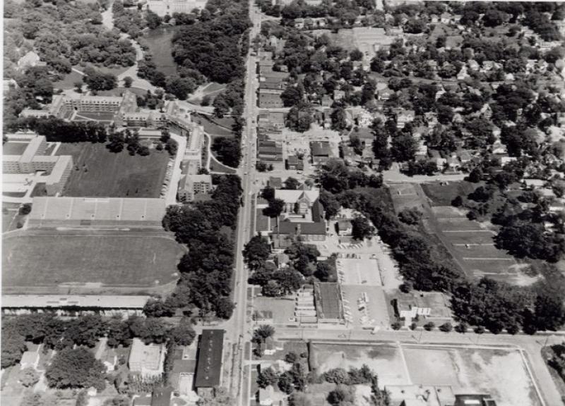
This 1959 Iowa Dept. of Transportation aerial is looking east from Sheldon Avenue at the area surrounding Lincoln Way, which bisects the photograph. In the bottom center (the north side of Lincoln Way) is the Lincoln Apartments building. Above that can be seen Clyde Williams Field, which was the Iowa State College/University playing field prior to the construction of the Jack Trice field and stadium on the south side of Lincoln Way between Beach Avenue and Elwood Drive. Above the Cyde Williams Field can be seen a number of dormitory buildings on the Iowa State campus. Above the dormitories are Lake Laverne and the Memorial Student Union. In 1959, the institution's name was changed from Iowa State College to Iowa State University. On the right side of the photograph (the south side of Lincoln Way) can be seen the Wesley Foundation Student Center, the Collegiate Methodist Church and the various buildings making up the campustown shopping area. On the east side of Sheldon Avenue (also, south of Lincoln Way) are the Hy-Vee Store and its parking lot and the Campus Baptist Church. This aerial was taken in preparation for the widening of Lincoln Way from two to four traffic lanes.
Citation: 200.1134.3
Year: 1959